Brief Respite from Heat, the Calm Before the Storm
Before the arrival of this round of severe weather, the Spanish peninsula experienced a brief period of stability on Tuesday. Although the impact of the isolated high-altitude low-pressure system (DANA) temporarily weakened, a heatwave continued to affect most of the peninsula and the Balearic Islands. Temperatures exceeded 35°C in many areas, with regions like the Guadalquivir Valley and southern Galicia approaching 40°C. In response, Spain’s State Meteorological Agency (AEMET) issued an orange heat alert for seven provinces: Cáceres, Toledo, Jaén, Cuenca, Huesca, Lleida, and Tarragona.
DANA’s Strong Return, Bringing Severe Convective Weather
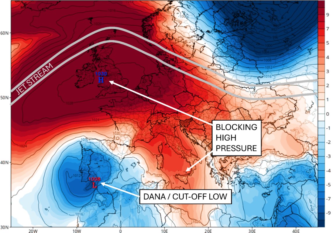
The brief spell of good weather will end starting Wednesday. The DANA system is approaching the Iberian Peninsula again, merging with a cold air mass from the Atlantic and triggering a new round of severe convective weather. Widespread rainfall is expected in inland Galicia, the Cantabrian coast, eastern Andalusia, Murcia, southern and eastern Castilla-La Mancha, the Iberian System, and the Pyrenees. Some areas may experience violent thunderstorms, hail, and sudden gusts of wind. Precipitation mixed with Saharan dust could also form ‘mud rain’. Although temperatures will begin to fall, the high could still reach 38°C in local areas like Murcia, making heat precautions essential.
Risk Peaks on Thursday with a Sharp Nationwide Temperature Drop
Weather forecasts indicate that Thursday will be the day with the highest weather risk this week, as the main body of the DANA system will cross the entire peninsula. Northern regions, including Galicia, Asturias, Cantabria, and northern Castilla y León, will face heavy rainfall. In the central, southern, and eastern regions, the rain will be less intense, but the precipitation may extend to the Balearic Islands. As a result, the entire country will experience a sharp drop in temperatures, with many areas seeing temperatures 5 to 10°C below the seasonal average. Nights will be noticeably cooler, and the difference between day and night temperatures will be significant.
Unstable Weather to Continue Through the Weekend
The rainfall is not expected to end on Thursday. According to forecasts, rainy weather will persist in the northern third of Spain on Friday. The heaviest rainfall will be in Cantabria and the Basque Country in the morning, with the focus of the precipitation shifting to the Pyrenees, the Iberian System, and Catalonia in the afternoon. This trend of unstable weather is expected to continue into the weekend.
Official Advisory: Beware of Sudden Weather Changes and Secondary Disasters
The meteorological department has issued a safety advisory, recommending that residents closely monitor the latest official weather forecasts and take precautions against potential secondary disasters such as flooding caused by short-term downpours, strong winds, and hail. Additionally, due to the drastic temperature changes, the public should adjust their clothing accordingly to avoid health risks associated with the sudden shift. While this DANA event is expected to end Spain’s prolonged heatwave, the accompanying risk of severe convective disasters should not be underestimated.
