Driven by an upper-level trough, Spain will experience a significant weather shift on August 21, 2026. The State Meteorological Agency (AEMET) indicates that most parts of the country will see a drop in temperatures, while the Mediterranean coast and northern regions will be hit by severe thunderstorms and showers, marking a temporary relief from the recent extreme heat.
Upper-Level Trough Triggers Severe Convective Weather
On August 21, 2026, the approach of an upper-level trough (vaguada) breaks Spain’s recent stable weather pattern. According to AEMET monitoring, starting in the early hours of the morning, the Balearic Islands will be the first to face a fierce thunderstorm system, potentially accompanied by damaging wind gusts. Meanwhile, localized heavy rainfall is expected along the Cantabrian coast. By the afternoon, convective activity will spread inland and to the northeast, covering areas such as the Iberian System in Aragon, Barcelona, and Girona with lightning and showers.
Nighttime Precipitation Intensifies Along the Mediterranean Coast
As the weather system progresses, atmospheric instability along the Mediterranean coast will further intensify on Friday evening. Meteorological authorities warn that the coastal areas of Catalonia and the northern part of Castellon province will face high-intensity, prolonged showers, with rainfall in some municipalities potentially reaching severe levels. In contrast, most central and western areas of the Iberian Peninsula will remain sunny or partly cloudy, with only parts of the inland Cantabrian region experiencing brief morning fog and low clouds at dawn.
Significant Cooling Across Multiple Regions Nationwide
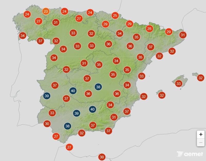
Another core feature of this drastic weather change is the widespread cooling across the country. AEMET data shows that on August 21, nighttime minimum temperatures in most parts of Spain will drop significantly. The decrease in daytime maximum temperatures will be particularly prominent in the Iberian System, Castellon province, and the Balearic Islands. In addition, temperatures in the northern plateau, northeastern regions, and the Mediterranean coast will also fall. However, influenced by topography and air currents, temperatures in the southwestern regions will slightly increase against the overall trend, while a few other areas will remain relatively stable.
Some Southern Cities Maintain High Temperatures
Although the overall climate is trending cooler and the extreme heat is easing, some core cities in the south and southeast are still not completely free from the sweltering weather. According to the latest weather forecast, among the capital cities, the maximum temperature in Murcia will still climb to 36 degrees Celsius that day, making it the hottest city in the country. Alicante is expected to reach 34 degrees Celsius, while peak temperatures in Seville, Malaga, Cordoba, Badajoz, Albacete, and Palma will hover around 33 degrees Celsius. While taking precautions against localized severe convective weather, residents in these areas still need to ensure adequate heat protection in the afternoon.
